|
|
| CLIMATIC AND AIR HYGIENE MAPS AS AIDS FOR PLANNING AND ZONING (EXAMPLE: CLIMATE ATLAS FEDERATION REGION STUTTGART) |  |
| | | |
 5.8 Maps with Recommendations for Planning 5.8 Maps with Recommendations for Planning |
A map with recommendations for planning (Figure 5/20 and Figure 5/21) contains an integrated assessment of the material represented in the climate analysis map as it relates to concerns relevant in planning. The symbols give recommendations as to the sensitivity of certain land areas to changes in land use, from which climatically-grounded conditions and measures can be derived in the context of planning and zoning.
The recommendations for planning primarily relate to structural changes of land use. For example, a change in the composition of vegetation exerts fewer climatic effects than large-scale soil capping measures and the erection of structures.
The planning recommendations are not specific to the level of individual parcels, and tolerances can range up to 100 m.
More detailed questions in connection with site plans must be dealt with through special appraisals when necessary, especially in areas of high climatic and air-hygienic sensitivity.
In addition to local characteristics, the following principles form the basis for the planning recommendations:
Areas of vegetation have an important effect on the local climate, since on the one hand they cause the nightly fresh/cold-air production and on the other they exert a balancing thermal effect when they feature a high proportion of trees. Green spaces in the city and nearby areas exert a positive influence on their immediate vicinity in a microclimatic sense; vegetation on the border of developments also contributes to air exchange. Larger, connected green spaces represent the climatic and air-hygienic potential for regeneration. Particularly in the present spatial context of the built-up area, such green spaces are very important for air exchange. As far as possible, therefore, open spaces should not be converted to development from a climatic perspective.
Development in valleys can also be judged as generally negative, since the movement of cold, fresh air takes place in valleys under weak wind conditions and since valleys serve as air delivery corridors for stronger regional winds.
Hillsides in extended built-up areas, should remain undeveloped, especially when development exists in valleys, since intensive cold- and fresh-air transport occurs here (however, development on southern hillsides is desirable from an energy conservation perspective û (see also Chapter 3)). The same is valid for gullies and ridges along these hillsides.
Saddle-like topographies on the backside of mountains serve as air induction corridors and should not be developed.
The climatic and air-hygienic perspective recommends encircling development with as much green space as possible as well as crisscrossing it with green corridors oriented to topographic features (e.g. ventilation passages; air induction corridors) and thus support air exchange.
Urban sprawl from numerous developments strewn across the landscape as well as the emergence of disruptive belts of built-up areas, e.g. through the convergence of neighboring communities, are to be avoided. Urban development must be accompanied by close, large fresh- and cold-air production areas and ventilation corridors.
The development of commercial and industrial enterprises should ensure that the residential areas in the immediate vicinity do not suffer from heightened emissions resulting from the local wind patterns.
More detailed descriptions of the individual symbols on the map "Recommendations for Planning" are given below.
OPEN SPACES
Open Spaces with Important Climatic Activity: Direct relation to built-up areas such as green spaces in the city or those that lie upwind from a mountain/valley wind system; undeveloped valleys, ridges, and gaps in terrain; large, connected open spaces near densely-settled areas. These open spaces exhibit a high sensitivity to changes in land use; that is, uses involving construction and soil capping lead to precarious impairments of climate. The same is valid for measures that hinder air exchange.
Open Spaces with Less Important Climatic Activity: No direct contact with developed areas or only minor cold-air production (e.g. rocky or fallow lands); less sensitivity to changes in land use. Large-scale development, as long as it does not substantially obstruct the regional air exchange, is possible.
Climatically-important local characteristics such as ridges, depressions, brooks, etc., however, are to be taken into consideration during planning. To obtain as small of an impairment on the climate as possible, the preservation of green spaces and corridors, roof and facade greening, the lowest possible building heights, and building orientations open to the wind are recommended.
Open Spaces with Minor Climatic Activity: Lesser influence on developed areas; lying at a distance from development; relatively unimportant for cold- and fresh-air production. Changes in land use are associated with only minor disturbances to climate. This includes, for example, hilltops and large-scale, well-ventilated areas with relatively level topography at a distance from any development.
Development such as skyscrapers or large-scale commercial enterprises is possible in these areas from a climatic perspective. It should be ensured, however, that the ventilation conditions remain unaltered relative to the main wind direction. The existing level of emissions is also to be taken into consideration, so that no sensitive land uses will be planned in the vicinity of enterprises and heavily-trafficked thoroughfares.
DEVELOPED AREAS
Developed Areas with Functions of Minor Climatic Relevance: Developed areas without high thermal or air-hygienic burdens that do not significantly impact neighboring areas of settlement.
No noteworthy climatic or air-hygienic sensitivity relative to intensifications of land use or expanded development is assigned to these areas (e.g. developed, well-ventilated hilltops).
Care must be taken so that existing ventilation conditions remain intact and that additional emissions do not bring about negative effects on other developed areas. Roof and faþade greening and the preservation of green spaces can prevent thermal problems.
Developed Areas with Functions of Climatic Relevance: Thinly-developed settlements with green spaces, which cool noticeably during the night and are relatively open to the wind; well-ventilated dense areas of development (e.g. hilltops). These areas produce neither intensive thermal or air-hygienic problems nor impediments of air exchange, and they generally exhibit low climatic and air-hygienic sensitivity to changes in land use.
This includes, for example, infill development and the closure of gaps in buildings, whereby the amount of developed land in the entire area is to remain constant.
Planning should attempt to keep soil capping measures in these areas to a minimum. They can be equalized by the creation of green spaces as well as roof and faþade greening.
Developed Areas with Functions of Significant Climatic Relevance: Loosely-developed, strongly-greened areas with low building heights on the periphery of communities with nearly undisturbed air exchange; hillsides with development at their feet (although these hillsides also contribute to cold air production); areas with singular freestanding skyscrapers and green spaces; densely-developed areas whose climatic and air-hygienic footprint is not exceedingly high.
The designated areas exhibit a substantial climatic and air-hygienic sensitivity relative to changes in land use.
Further development and soil capping measures lead to negative effects on the climatic situation. Instead, an enlargement of the proportion of green space and the securing or expansion of ventilation spaces is recommended for these areas.
Developed Areas with Climatic and Air-Hygienic Disadvantages: Densely-developed areas that have strong climatic and air-hygienic problems; including those developed areas whose air exchange is considerably hindered by buildings. These areas require restructuring under urban climatic criteria (increasing the proportion of green space; minimizing the amount of soil capping; minimizing the level of emissions, especially traffic emissions; creation or expansion of greened ventilation corridors; removal or relocation of disruptive buildings where necessary).
Roads with High Air and Noise Pollution: Main traffic thoroughfares with a traffic count of more than 15,000 vehicles per day. The resultant high levels of air and noise pollution must be taken into consideration in planning.
Sensitive land uses such as residential areas, recreational areas, and agricultural lands should be planned only at sufficient distances from roads or with adequate protection measures. (Important: An immissions prognosis is required! (see also Chapter 4.2 and Chapter 4.3)).
|
|
| | | |
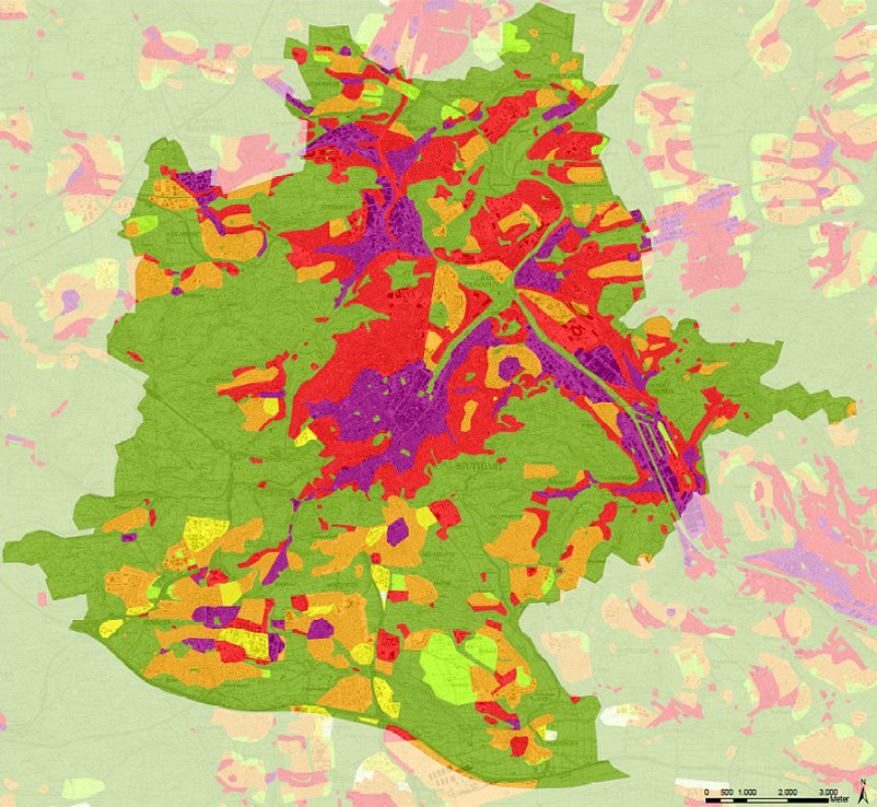 |
| Fig. 5/20: Map with Recommendations for Planning, Stuttgart area, Source: Climate Atlas Region Stuttgart 2008 | | |
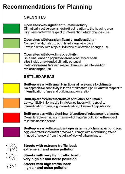 |
| Fig. 5/21: Key to the Map with Recommendations for Planning, Source: Climate Atlas Region Stuttgart 2008 |
|


