|
|
| CLIMATIC AND AIR HYGIENE MAPS AS AIDS FOR PLANNING AND ZONING (EXAMPLE: CLIMATE ATLAS FEDERATION REGION STUTTGART) |  |
| | | |
 5.6 Forecasting the Effects of Climate Change: 5.6 Forecasting the Effects of Climate Change:
Mean Annual Temperature and Bioclimate |
What is studied in more detail besides the climatic situation is the changes arising from global climate change. The prognosis examines the change of the average annual temperature and the resulting implications for the bioclimate. The climate prognoses by the Intergovernmental Panel on Climate Change (IPCC) expect a global temperature increase of about 1.4 to 5.8 K in this century.
The temperatures in turn have a strong influence on the bioclimate. Bioclimate means the entity of all atmospheric influences on human beings. Factors like heat, cold and air humidity strongly influence people"s well-being, working capacity and health. For one thing, the climate atlas shows the actual situation as for heat and cold stress on the basis of long-term measurements. What we can see is an expected area of about 5 % with more than 30 days with heat stress resulting from high perceived temperatures in this region. Numerous epidemiological studies prove that the adaptability of sensitive people will then be overstrained more quickly – especially in the case of a predisposition for cardiovascular and respiratory diseases. This may lead to an increasing number of fatalities.
With regard to the temperature increase due to the global climate change, we try to look further ahead and go beyond the current situation. This is realised through a prognosis based on the assumption that the number of days with heat stress will double in the case of climate warming. The result is that large parts of Greater Stuttgart (57 % of its territory) would have to expect more than 30 days with heat stress, i.e. that a significantly higher percentage of people would be exposed to heavy heat pollution during the summer. The legend to the bioclimate maps reveals a range of 2.5 to 35 days.
The maps compare the actual situation (Figure 5/8a) determined by the German Meteorological Service with the prognosis expecting a temperature increase of 2 K (Figure 5/8b).
The prognosis shows that this will be a big challenge for regional planning. What plays a major role in this context is the preservation of climatic compensation areas on which fresh and cold air is produced and the guaranteeing of sufficient aeration.
The impact of climate change is set to affect almost all areas of life. To prognosticate the impact and affectedness for different regions, vulnarability studies are carried out. These studies contain e.g. forecast maps showing risk of storm damage, eligibility of tree species or the vulnerablility of the population (see Figure 5/9).
Within a model-like project is stated for the region of Stuttgart an above-average affectedness by the impact of climate change. This climate impact contains frequently flooding, displacement of thermosensitive plants, hazard of erosion and not least a higher heat exposure of people.
Therefore the formation „Region Stuttgart“ encourages specific measures which are weighty relevant on a regional level, e.g. saving climate-relevant unused space. More information is available in terms of the final report “Vulnerabilität in der Region Stuttgart“ (to obtain from http://www.region-stuttgart.org). In future climate analyses and dedicated maps should outline vulnerablities persuant the expected future situation.
|
|
| | | |
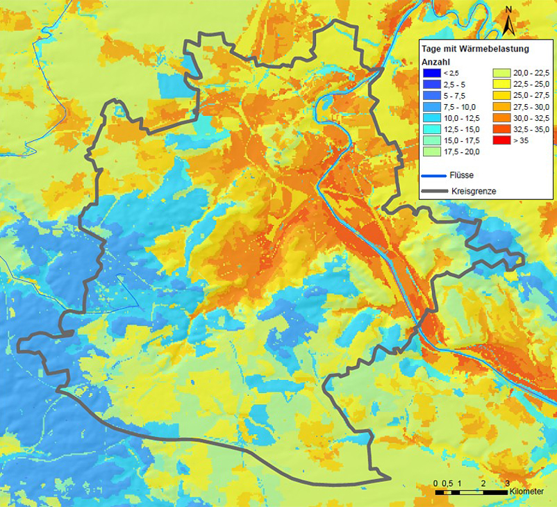 |
| Fig. 5/8a: Bioclimate days with heat stress 1971 - 2000, Source: Climate Atlas Region Stuttgart 2008 | | |
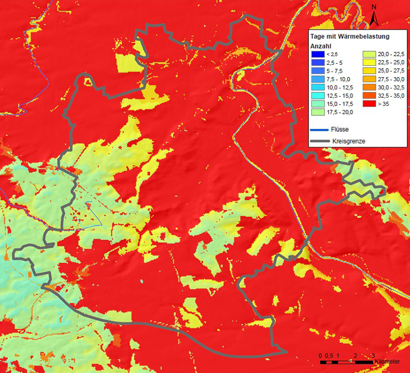 |
| Fig. 5/8b: Bioclimate forecast days with heat stress 2071 - 2100, Source: Climate Atlas Region Stuttgart 2008 | | |
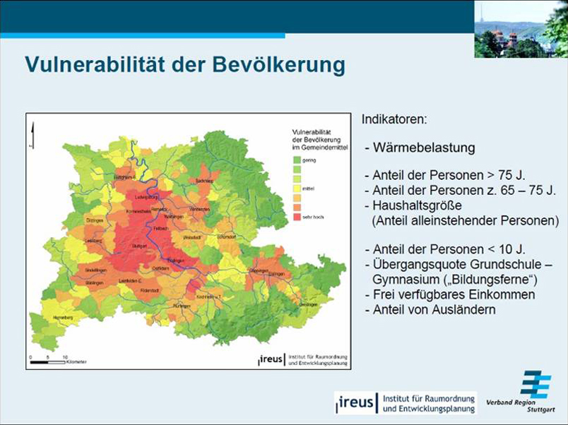 |
| Fig. 5/9: Vulnerability in the Stuttgart Region, Source: Department of Planning and Development Planning Region Stuttgart |
|


