|
|
| METHODS OF INFORMATION ACQUISITION FOR PLANNING
(MEASUREMENTS, WIND TUNNELS, NUMERICAL MODELLING) |  |
| | | |
 4.3.5 The Model PROKAS for Calculating Air Pollution on Roads 4.3.5 The Model PROKAS for Calculating Air Pollution on Roads |
The model PROKAS (BOESINGER, 1996; VDI 3782, Section 8) calculates air pollution along roads on the basis of a Gaussian dispersal model for individual sections of road and road networks. For the calculation of emissions on roads with dense peripheral development, an integrated building model is employed that uses results based on calculations with MISKAM (see Chapter 4.3.6) as well as results from wind tunnel studies and field experiments.
The emissions densities for individual sections of road are essentially determined by the traffic volumes, the type of driving, the reference year, and the time-elapsed emissions curves of the emissions factors (see Chapter 2.8.1).
In addition, the use of PROKAS requires representative dispersal class statistics with data about the wind velocity, wind direction, and dispersal class distribution.
Comprehensive immission calculations
Figure 4/24 show comprehensive immission calculations for nitrogen dioxide (analysis and prognosis), created through a combination of the PROKAS and LASAT models and the KLAM cold air model. Besides road traffic, the other pollutant source groups (domestic fire, business and industry) were also considered as emissions.
The simulation software LASAT (JANICKE, 1996; VDI-Richtlinie 3945 Bl.3, 2000) calculates the distribution of pollutants by simulating the transport and the turbulent diffusion of a group of representative parts in a stochastic process (Lagrange-Simulation). The information about the wind is fed by three-dimensional windfields. LASAT offers the possibility to regard the terrain and its influence.
More information on comprehensive calculations are available at:
http://www.stadtklima-stuttgart.de/index.php?luft_flaechenbelastung_stgt
|
|
| | | |
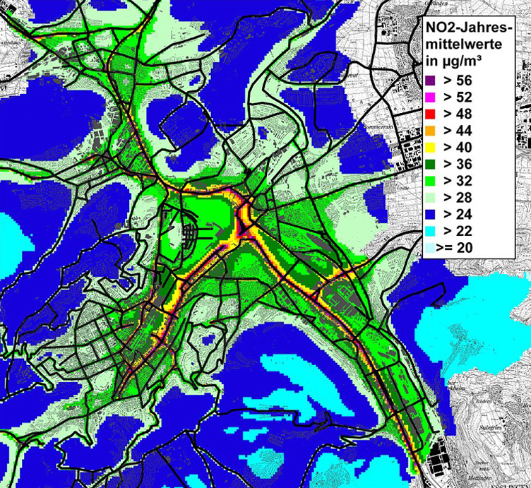 |
Fig. 4/24: Areally NO2 levels in Stuttgart (detail) , forecast for 2015,
Source: Lohmeyer, 2009 |
|


