Deutsch      Englisch       

Home
Preface
Sitemap
1.Climate as a Public Interest in Planning and Zoning
2.Characteristics and Forms of the Urban Climate
3.Energy-Conscious Planning and Zoning
4.Methods of Information Acquisition for Planning (Measurements, Wind Tunnels, Numerical Modelling)
4.1Measurements
4.1.1Stationary Measurements
4.1.2Measurements with mobile measurement devices
4.1.3Tracer Experiments
4.1.4Vertical Soundings
4.2Wind Tunnel
4.2.1Overview
4.2.2Operation and Investigation Methods
4.2.2.1Visualization of flows and pollutant dispersion by smoke
4.2.2.2Wind Velocity Measurements
4.2.2.3Measurement of Concentration Distribution in Dispersal Experiments
4.2.3Locations of Wind Tunnels
4.3Numerical Modelling of Flow and Transport Processes
4.3.1The Wind Field Model DIWIMO
4.3.2The Cold-Air Flow Model KALM and KLAM 21
4.3.3The Model STREET for Estimating Traffic-Produced Pollution
4.3.4The Model MLuS-02 for Calculating Pollutant Dispersal
on Roads Without Dense Peripheral Development
4.3.5The Model PROKAS for Calculating Air Pollution on Roads
4.3.6The Micro-Scale Model MISKAM
4.3.7Mesoscale Terrain Climatic Models
4.3.8The Urban Climate Models RayMan , ENVI-met and MUKLIMO_3
5.Climatic and Air Hygiene Maps as Aids for Planning and Zoning (Example: Climate Atlas Federation Region Stuttgart)
6.Recommendations for Planning
7.Bibliography
8.Thematic Websites
Imprint
Download
 
METHODS OF INFORMATION ACQUISITION FOR PLANNING (MEASUREMENTS, WIND TUNNELS, NUMERICAL MODELLING)
   
 4.1.4 Vertical Soundings

The study of the spatial dimension of climatic processes also demands the consideration of the "third dimension" and thus the measurement of vertical structures in the urban atmosphere. For this purpose, traditional measurements with the help of balloon-carried, free-flying radio probes or anchored balloon flights (Figure 4/6a) can be employed. SODAR and LIDAR are ground-based measurement procedures with the option of continuous vertical sounding (Fig. 4/6b). These project sound waves (SOnar-RaDAR) or laser light waves (LIght-RaDAR) into the atmosphere, and the reflected returns are measured (via the Doppler Effect). With this, wind direction and velocity can be measured in individual increments of altitude between about 20 m and 600 m. The RADAR-procedure is typically used for altitudes above 600 m.


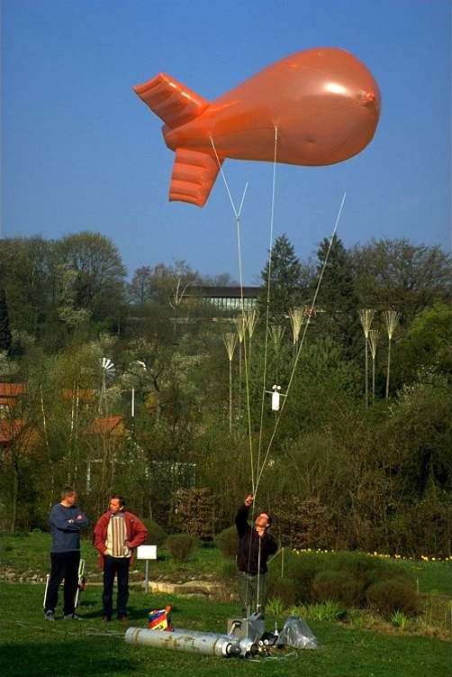
Fig. 4/6a: Captive balloon with measuring instrument
 
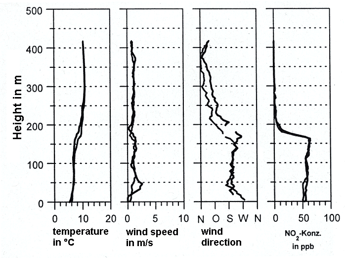
Fig. 4/6b: Vertical sounding of temperature, wind, and nitrogen dioxide in Stuttgart in April morning; BAUMBACH et al., 1999